Many industries benefit from ArcGIS software. While the most obvious ones might be for construction and urban planning, healthcare, telecommunications, and real estate are other industries that leverage its capabilities.
Blog
Let's Talk !
Chetu is an Esri Silver partner with an Esri Release Ready specialty. Our certified Esri GIS experts have tremendous backend industry experience in telecommunications, transportation, AEC, retail, real estate, and more, providing unparalleled technical & non-technical ArcGIS services.
Chetu's developers create both local and global mapping and scenes to give you a better visualization of geospatial content, including multiscale basemaps, map layers, camera views, and more. We also configure RDBMS to manage GIS data and create custom GIS database designs.
Our ArcGIS consultants configure and implement customizable location data and geospatial analytics modules within your ArcGIS platform as a comprehensive Platform-as-a-Service (PaaS) to streamline workflows, improve operations, and meet all of your unique business needs.
Chetu’s ArcGIS developers collectively bring data together, creating an all-in-one business solution to improve overall business efficiency. Our experts will seamlessly integrate the Esri ArcGIS platform with any third-party or proprietary internal business software, system, or application.
Chetu’s ArcGIS experts build innovative apps from the ground up and enrich your existing Esri ArcGIS AI integrated application with authoritative data by integrating powerful location capabilities, creating high-quality 2D & 3D visualizations, and performing advanced spatial analytics for more precise insights.
Chetu’s highly regarded expertise in building custom geo-enabled applications designed to automate workflows and increase business efficiency makes us the go-to ArcGIS application development company to rely on for all of your unique app development needs.
Using REST & SOAP for JSON & XML data interchanges to analyze and display real-time location-based data, we’ll program a complete set of premier on-demand location mapping and data visualization capabilities into your web or mobile application, including:
Basemaps
Geocoding & Search Functions
Data Hosting Features
Global Maps & Data
Spatial Analytics
Mapping APIs
Routing & Directions
Our Esri professional services provide full access to web and native client SDKs and APIs, Chetu’s ArcGIS consultants implement the latest GIS technologies into your current business systems, enabling users to track, coordinate, and share location data, thus building stronger team awareness and comprehensive P2P communication in disconnected environments.
With our custom ArcGIS solutions, users can visualize and transform any location data into comprehensive 3D models, thus enabling businesses to identify and solve problems, stay on top of current trends, and make smarter decisions.
Our ArcGIS consultants design quantitative and qualitative symbols, transitions, overlays, objects, legends, classifications, and many other 2D & 3D design elements that enable users to visualize 2D and 3D thematic maps with ease.
We leverage ArcGIS 3D Analyst, ArcGIS Pro, ArcGIS Image Server, ArcGIS Online, and several other ArcGIS products to visualize, create, and manage high-quality aerial (drone) and terrestrial LiDAR mosaic datasets and 3D scenes.
Whether you require data migration or conversion stored in a BI data warehouse, ERP system, CRM solution, or other business processing system, Chetu will help you maintain 100% data integrity throughout the entire process.
We leverage Esri’s ArcGIS Spatial Analyst extension to perform advanced hydrologic & statistical analysis, model & analyze terrains, find suitable routes & locations, uncover spatial patterns, model risk factors, and estimate cost-effective routes.
Chetu’s ArcGIS programmers provide customized Esri system architecture design & consulting services, developing strategic GIS selection & implementation plans that are custom-tailored to your industry niche requirements.
Along with implementing Esri ArcGIS tools with existing systems, we engineer custom ArcGIS solutions, applications, extensions, and plugins to extend your system functionality, providing a solution that best fits your unique business needs.
Our Esri developers leverage the ArcGIS REST API for Python, JavaScript, C#, and PHP to allow us to work with the ArcGIS platform through web services and perform, assist, and automate a variety of scripting server administration tasks within ArcGIS Server.
Our Esri developers have extensive experience leveraging ArcGIS Pro’s geoprocessing tools, enabling us to build an infinite number of custom tools that automate repetitive GIS tasks, solve complex problems, and perform advanced spatial analysis.
We leverage Esri’s GeoEnrichment module to retrieve information about the people & places in a specific location or area within a certain distance from a location, such as demographics (population, income, housing, consumer behavior, and natural environment.)
Available with ArcGIS Enterprise, our development experts perform advanced Raster Analysis (within the ArcGIS Raster Analytics module), that incorporates terrain analysis, vegetation analysis, suitability analysis, and persistent imagery product generation.
Leveraging the ArcGIS Data Interoperability Extension enables our developers to customize your file formats and dataflows by creating or modifying spatial ETL (extract, transform, and load) tools within the FME Workbench visual workflow editor.
Using ArcGIS Web AppBuilder, our programmers can configure and customize your fully featured HTML/JavaScript application using many out-of-the-box widgets, along with customizable templates, themes, maps/scenes, and attributes.
PathVu, a worldwide sidewalk network software company, chose Chetu to create & implement a mobile app to improve accessibility and walkability along sidewalks using ArcGIS Map, ArcGIS Enterprise, and Lidar Point Cloud files.
Chetu takes Esri software to new heights with AI for enhanced data analysis to transform workflows, deploy real-time predictive modeling to elevate project quality, reduce expenses, and create actionable data insights. Mitigate project risks, automate spatial data mining and analysis, and modernize urban planning processes.
Chetu’s integration experts leverage AI to provide accurate, error-free analysis of all geographic worksites to expedite project completion, promote data-driven insights, and innovate urban planning processes. AI enables optimum resource allocation and unprecedented workflow efficiency to unlock the newest geographical insights to streamline protocols and modernize operations.
Our AI specialists design powerful, predictive analytics and modeling algorithms to forecast future data-driven outcomes accurately. Chetu programs AI-driven analytics to provide project managers with enhanced decision-making data to study all project metrics in diverse environments: urban planning, disaster response, and environmental management.
Chetu leverages customized IoT-driven resources to seamlessly integrate Esri GIS to capture nuanced, error-free geospatial data in real time. Collecting data from weather stations and other pertinent sources with intuitive sensors, Esri GIS provides connected end-users with accurate maps and geography details to promote actionable insights to drive decision-making processes.
Our dedicated developers design and implement cutting-edge pattern mining and modernized Machine Learning resources to glean unprecedented insights into pattern recognition and underlying risk factors. Chetu collaborates with urban project planners and traffic management personnel to accurately identify high-risk areas for vehicular accidents, unlocking actionable insights to reduce safety threats and traffic congestion.
Chetu’s certified Esri developers have extensive knowledge and experience working with all ArcGIS products and solutions, providing expert-level software system consultations, implementations, integrations, modifications, deployments, and IT support.
Our ArcGIS Urban integration combines powerful 3D GIS technology along with built environment data to provide engineers, city planners, and urban designers with the information they need to model cities in 3D. Its integrated navigation and analysis tools make it easier to visualize and analyze the data with unprecedented accuracy.
Our ArcGIS Reality services enables businesses to combine the physical and the digital worlds in a single, unified 3D plugin. These cloud-based services allow users to see, interact with, and analyze content in 3D such as buildings, infrastructure, point clouds, or terrains.
Our experts will deploy your custom ArcGIS Enterprise solution so that you can create custom maps, analyze your geospatial data with ease, and share your results with others inside or outside your organization.
We’ll implement the ArcGIS Pro app with your systems so you can visualize, analyze, govern, and maintain your data in 2D, 3D, and 4D displays. You can also share your data across a suite of other ArcGIS products.
We’ll provide ArcGIS GeoBIM as a powerful suite of Esri’s building information modeling (BIM) products for creating, managing, and interpreting 3D visualizations of the built environment. It offers GIS information such as location, boundary, address, and building type, fused with engineering data such as material and construction type.
We’ll provides ArcGIS Indoors as a comprehensive solution for interactive indoor mapping and navigation. It allows turns complex indoor spaces into an immersive experience by incorporating data such as space and room information, 3D features, access control, and more.
We’ll deploy ArcGIS Online, Asri’s advanced web-based mapping system so that you can easily collaborate with your team, share insights, and gain intuitive location intelligence using interactive data-driven mapping styles.
Our experts will handle your data hosting efforts, securing your data in the cloud or behind your firewall systems. We’ll also manage, query, and edit your data using ArcGIS tools along with your own business applications.
Chetu’s experts use core GIS software tools and the latest geospatial modeling technologies to enhance mobile communications and introduce new innovative ways for your business to utilize GIS data to increase business effectiveness.
Find the quickest and shortest routes with fewer stops in-between. Take into close consideration real-world constraints, including traffic, road barriers, maximum permitted vehicle height, u-turns, incidents, etc.
Generate turn-by-turn navigation/directions as you travel on the route in real-time, tracking progress information that’s relative to the next stop along your entire route while receiving voice guidance along the way.
A network service area describes a region that can be reached from a specific location within a given distance or travel time. Once a service area is created, you can use them to identify market areas quickly and easily.
Identify where all the closest facilities are based on your preference or reason for travel, including emergency facilities like hospitals or fire stations, all while providing you with the best routes and directions.
Find a location, via analysis that proves where particular goods and services are consumed, that keeps costs low and maintains high visibility on the road, enabling you to maximize profits and ensure high-quality service.
Minimize the overall operating costs of your entire fleet while considering real-world constraints, thus determining/prioritizing which stops should be serviced by each route via their proper sequence.
As an Esri Silver Partner with certified Esri GIS experts, Chetu offers support services for Esri applications. Chetu’s expertise with GIS (geographic information systems) and the Esri ArcGIS platform makes Chetu uniquely qualified to offer support and services, including troubleshooting, advanced customization, management, analysis, and distribution of raster and imagery data collections.
Chetu’s software engineers provide comprehensive support services and assist with account creation and setup, map configuration and design, and cloud-based GIS functionality of an ArcGIS-based SaaS platform that uses the cloud-based GIS functionalities and offers content management, data hosting, analytics, real-time reporting, downloadable reports, a spatial database, georeferencing, and more.
Our team supports the seamless transfer of geospatial data from various and diverse sources into your ArcGIS platform. Using System Design Strategies that align with ArcGIS specifications, data formats are converted, mapped, and structured within ArcGIS so that data integrity is maintained and the ability to perform mapping data structures remains accurate.
Our experienced staff of ArcGIS experts can support scalable infrastructure, define new workflows, and integrate GIS components as standalone services or as integral parts of your platform. We can design system architecture for a seamless and effective platform that meets or exceeds your business goals.
Our engineers create, upgrade, and maintain Esri GIS software to encompass a wide range of digital mapping products and support analyzing maps with the ArcGIS platform. Our support includes map production and creation, geospatial data mapping including thematic data mapping, spatial analysis using advanced GIS tools, and generating geographic data for actionable insights.
Our team supports your Esri ArcGIS cloud services with comprehensive assistance for your cloud ArcGIS solutions. Our support includes help with new installations and continuing management of cloud-based GIS infrastructure, migration planning, architecture design, and cloud platform selection. Chetu also provides support for QGIS (Quantum GIS) solutions.
Our experts leverage ArcGIS spatial analysis techniques from your topographic mapping utilizing data from the GPS and using geospatial analysis to obtain meaningful geographic data that is used for spatial statistics, network analysis, spatial queries, and other data that is used to discover patterns, relationships, and trends.
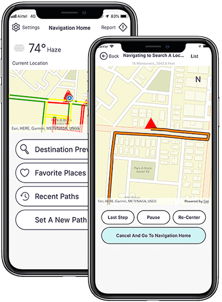
Chetu’s certified ESRI GIS specialists have backend industry experience in Transportation, AEC, Telecommunications, and more to provide unparalleled services for ArcGIS Cloud, Desktop Suite, and Mobile toolbox.
Chetu’s Block of Hours program is a cost-effective alternative to our standard flat-rate support offered to new, current, and past customers. Our dedicated Esri ArcGIS specialists are quick to relate and bring added value to your ArcGIS platform through our implementation, modification, integration, deployment and support services.
We offer technical and non-technical support services for all ArcGIS products. Services are sold per 100 Block of Hours with reduced rates contingent on hours purchased. Our lowest rates are attained when utilizing our full-time, dedicated resource(s).
Many industries benefit from ArcGIS software. While the most obvious ones might be for construction and urban planning, healthcare, telecommunications, and real estate are other industries that leverage its capabilities.
Computer vision is a type of deep learning used for GIS, satellite, aerial, and drone imagery. One notable use is image classification, where a computer assigns a label such as “car” or “plane.” It is used in GIS to categorize geotagged photos.
There are a few notable cloud storages for GIS data, such as Amazon Web Services (AWS), Google Cloud Platform (GCP), and Microsoft Azure. These are typically used for power, storage, database, networking, and Machine Learning.
ArcGIS facilitates spatial mapping and analysis through its suite of tools for data management, visualization, and spatial analysis. Using geoprocessing, users harness customizable maps, conduct analytical tasks, and automate workflows.
Primarily, by combining information derived from real-time spatial analysis and other business data, SAP HANA will enable you to improve your decision-making, resulting from ArcGIS implementation. It optimizes resource allocation and route planning.
ArcGIS is suitable for desktop and web-based environments. Its functionality is enabled on both platforms by ArcGIS Desktop and ArcGIS Online/Enterprise.
Drop us a line or give us a ring. We love to hear from you and are happy to answer any questions.
REQUEST A CONSULTPrivacy Policy | Legal Policy | Careers | Sitemap | Referral | Contact Us
Copyright © 2000-2024 Chetu Inc. All Rights Reserved.